
Underwater Hazards in the Delta: What Lurks Beneath
Discover tips on how to identify and avoid the Delta's hidden dangers—from seasonal debris flows to prop-fouling vegetation. We'll map out known trouble spots and share detection techniques that could save your boat.
*DISCLAIMER: This blog is not intended to create fear, but to educate and raise awareness. A single tip can save your day—or even your boat. Many boaters have safely navigated the Delta waters for years and have either avoided these hazards entirely or handled them without issue. By staying alert and sharp as the captain of your vessel, and remaining well-versed in potential risks, you’ll be well-equipped for the safest and most enjoyable experiences on the water.
The California Delta is an amazing place. Glassy water, open channels, sprawling sloughs stretching toward the horizon — it's one of the most beautiful boating destinations on the West Coast (if you missed it, see our Intro to this blog series here). But beneath that sometimes murky surface, lurks hazards that are worth mentioning.
The Delta is not a passive waterway. It's a living, shifting system of over 1,000 miles of waterways shaped by tidal forces, Sierra snowmelt, agricultural operations, and decades of infrastructure build-up and abandonment. What you see above the waterline tells you almost nothing about what's waiting below it. Even experienced Delta boaters who've run the same channels for years can find themselves suddenly aground, wrapped up in vegetation, or limping back to the dock on a fouled prop.
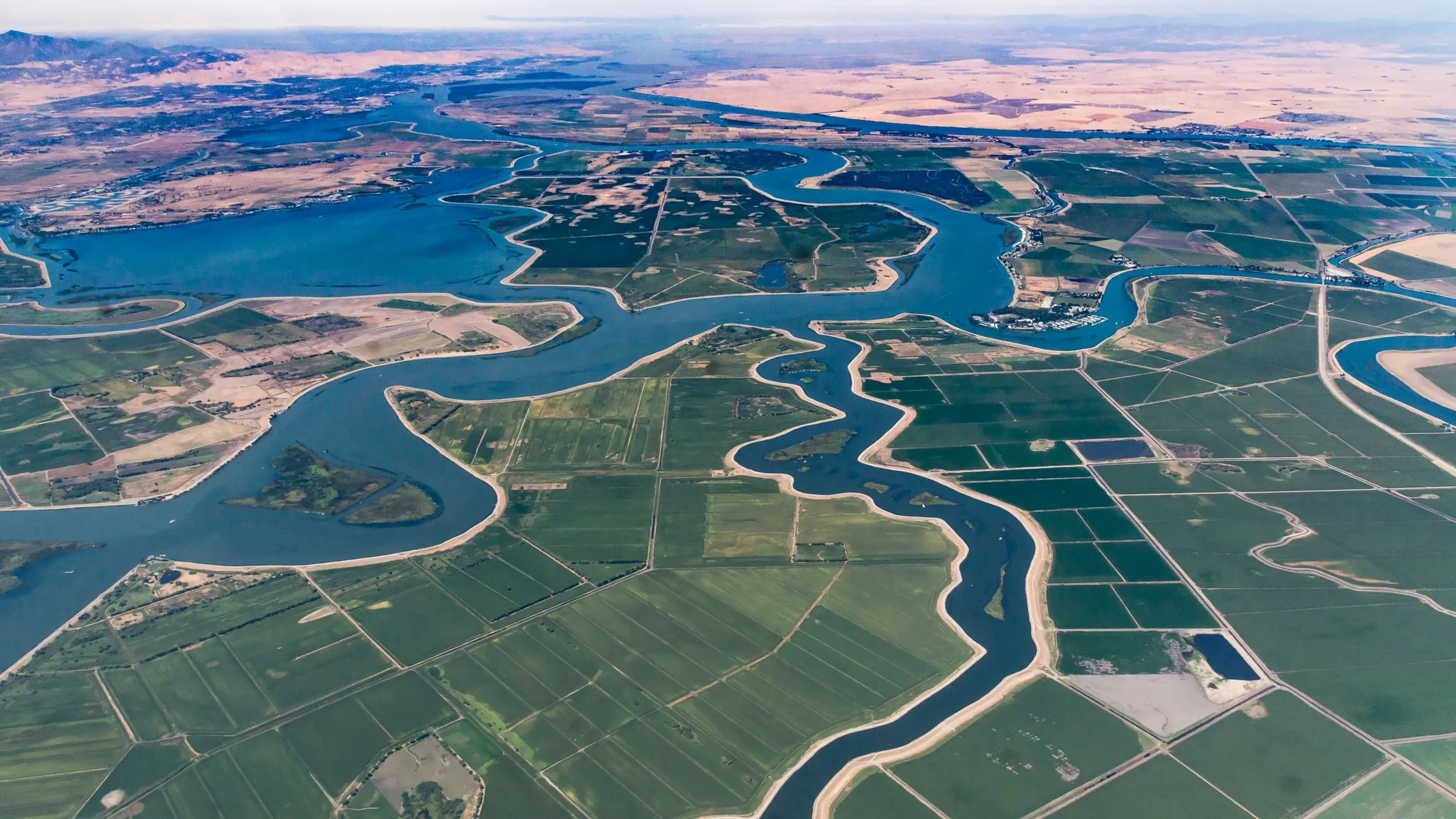
The Delta is a shifting system of over 1,000 miles of waterways.
This guide is a helpful underwater field manual. Whether you're a weekend cruiser, a fishing regular, or a live-aboard making seasonal runs, understanding what lies beneath — and where, and when — is the difference between a great day on the water and a costly, frustrating rescue operation.
The Delta Is Uniquely Complex & Hazardous
Before diving into specific hazards, it helps to understand why the Delta is so much more unpredictable than other California boating destinations.
Water Visibility is unpredictable and less than ideal at times. The Delta's water is turbid and tannin-stained year-round. Unlike coastal or lake environments where you might spot a submerged hazard through clear water, the Delta offers no such luxury. If something is down there, you won't see it until you hit it.
The tidal swing changes everything daily. The Delta experiences a 4–6 foot tidal range, which means a channel that offered comfortable clearance yesterday morning may snag your running gear this afternoon. Hazards don't move — your relationship to them does, twice a day, every day.
Seasonal runoff reshapes the waterway. Sierra snowmelt and winter storm systems push debris, sediment, and biological material through the Sacramento and San Joaquin rivers from January through May. The Delta you navigate in July is meaningfully different from the one you navigated in February, even on the exact same route.
Man-made hazards layer on top of natural ones. The Delta has been farmed, dredged, ferryed, mined, and developed for over a century. Much of that infrastructure is still out there — underwater, unlit, and in many cases, uncharted.
What Actually Lurks Down There
Seasonal Debris Flows
Winter in the Delta means water — and everything the water carries with it. Storm systems moving through the Central Valley flush agricultural debris, structural debris, uprooted vegetation, and timber downstream through the Sacramento River, San Joaquin River, and Mokelumne River tributaries. By the time that material reaches the central Delta, it's spread across channels, collected in eddies, and pushed into sloughs where it sits and accumulates - until it may move again.
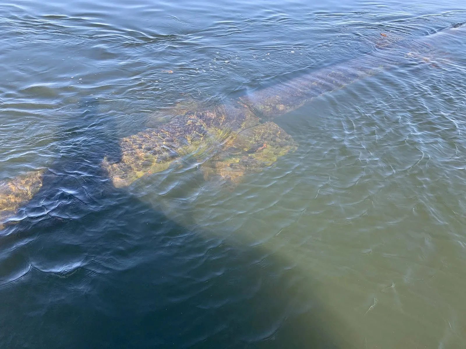
Peak debris season runs from January through April, though late-season storms can push it into early summer. The biggest threat during this period is the deadhead: a partially waterlogged log floating vertically just beneath the surface. Deadheads have almost no surface signature. At speed, you may see a subtle wake disturbance or a slightly darker patch on the water — and then you've hit it. The force transferred to a running drive or lower unit can be catastrophic.
Beyond raw timber, agricultural debris is a serious and under appreciated hazard. The Delta is surrounded by reclaimed farmland, and flood events regularly displace irrigation pipe sections, plastic sheeting, baling wire, and other farm infrastructure into open water. These materials are particularly dangerous because they're soft enough to pass over your depth sounder's cone without a strong return — but hard or dense enough to foul a prop or jam a cooling intake.
The Delta is surrounded by reclaimed farmland, and flood events regularly displace irrigation pipe sections or bring abandoned infrastructure to the surface, some of which will sink again.
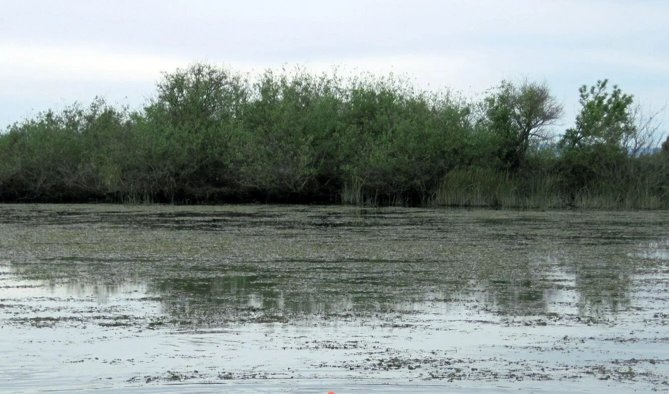
Prop-Fouling Vegetation
If debris is the Delta's winter hazard, vegetation is its summer nemesis, although many agencies and environmentalists are working on solutions.
Water hyacinth is the most notorious offender. An invasive species introduced from South America, hyacinth forms dense, interlocking mats on the Delta's surface that can stretch for acres. The mats are thick enough to slow or stop a vessel, prop-fouling is nearly instantaneous once you enter one, and cooling water intakes can be blocked within seconds. Hyacinth expands aggressively from June through October, driven by warm water temperatures and high nutrient loads from agricultural runoff. In a bad bloom year, almost entire sloughs become impassable.
Brazilian waterweed (Egeria densa) is the sneakier threat. It grows submerged — invisible from the helm — in dense beds throughout the Delta's shallower channels. You won't see it until your prop is wrapped and your boat is losing power. It thrives in warm, slow-moving water and is especially prevalent in the south and central Delta.
Tule reeds and cattail root mats line nearly every Delta shoreline and extend underwater from the bank edge further than most boaters expect. Approaching a tule shoreline — even at idle — risks fouling your running gear on root systems that may extend 5–10 feet out from the visible vegetation line.
Learning to read vegetation from a distance is a skill worth developing. Hyacinth mat edges often show as a distinct color change at the water surface, a foam line where mats meet open water, or a concentration of birds perched on what appears to be nothing. A slight reduction in surface ripple or chop near a mat edge is another useful indicator.
Vegetation is the Delta’s summer nemesis, however many agencies and environmentalists are working on solutions.
Submerged Infrastructure and Hard Hazards
The Delta's human history runs deep — literally. Generations of dock construction, ferry operations, agricultural development, and marina build-out have left behind hard infrastructure that has been abandoned, decayed, or simply forgotten. Much of it is not on any chart.
Old pilings and dock remnants are scattered throughout the central Delta, often in areas that once supported active commercial operations. Ferry landings, fuel docks, and working marinas that ceased operation decades ago left behind their underwater foundations. Treated timber pilings can persist underwater for 50 years or more. A cluster of pilings just below the surface in a channel bend — with no marker, no charted notation, and no visual warning — is exactly the kind of hazard that ends seasons and sinks boats.
Levee riprap is one of the most consistently misunderstood hazards in the Delta. The rock armoring that protects levee faces extends well underwater beyond the visible bank edge. During high-water periods, when the bank appears clear and the water looks navigable close to shore, that riprap is still out there — just hidden by the elevated water level. Running tight to a levee bank in these conditions is a reliable way to find it.
Submerged irrigation infrastructure is particularly dense near the Delta's agricultural channels. Intake pipes, culverts, and associated hardware extend from the bank into the channel bottom. These structures are generally not marked and are rarely charted at the recreational boater scale.
Derelict and sunken vessels are a growing problem throughout the Delta. The U.S. Coast Guard maintains records of known wrecks, but identification and removal lag far behind the rate of abandonment. Semi-submerged vessels in sloughs and side channels are sometimes visible; fully sunken ones are not. In low-traffic channels especially, assume the possibility.
Shifting Sandbars and Shoals
The Delta's bottom is not static. Dredging cycles, flood scour events, and ongoing sediment deposition from upstream constantly reshape and or redistribute the shallows — sometimes dramatically between seasons.
Channel bends and confluence points are the highest-risk zones. Where two waterways meet, current dynamics deposit sediment unevenly, and shoaling can develop faster than chart updates can capture. The same applies to areas adjacent to active agricultural operations, where levee maintenance and drainage activity regularly disturb and redistribute bottom material.
This is where chart currency becomes critical. NOAA charts reflect surveyed conditions at a specific point in time — often years in the past. A chart that shows 6 feet of depth at a particular point may be accurately depicting conditions from a survey conducted before a major flood scour or deposition event. Your chartplotter is showing you historical data, not real-time depth.
The tide compounds this. A channel that shows 6 feet at high water may offer 2 feet — or less — at low tide. If you're running an unfamiliar route, always calculate against low-water depth, not the average.
Mapping the Trouble Spots
Certain areas of the Delta have established reputations as high-risk zones. This is not an exhaustive list, but these are the locations that generate the most incidents:
Zone Primary Hazard Peak Risk Period
Frank's Tract State Recreation Area. Vegetation mats, submerged structure June–October
Mildred Island Hyacinth mats, shallow shoaling Summer
False River Debris flows, derelict vessels January–May
Steamboat Slough Deadheads, fast-current debris Winter/Spring
Old River / Middle River junctions Sandbars, unmarked pilings Year-round
Snodgrass Slough Vegetation, tule mats Summer/Fall
South Delta agricultural channels Irrigation infrastructure, baling debris Post-flood
Stockton Deep Water Channel approaches Hard bottom debris, submerged industrial remnants Year-round
Frank's Tract deserves special mention. What appears on the chart as a large open body of water is, in reality, a shallow, structure-laden area with a complicated history of flooding and submergence. Vegetation mats can cover significant portions of the Tract during peak summer months, and the submerged remnants of the original farmland infrastructure — fence posts, road beds, building foundations — are still out there beneath the mats.
Detection Techniques: Finding Hazards Before They Find You
Pre-Trip Intelligence
The best hazard detection happens before you leave the dock.
Cross-reference NOAA Chart 18660 series with the latest Notice to Mariners corrections. The corrections are free, regularly updated, and capture changes that the printed chart doesn't reflect.
Check CDFW Aquatic Invasive Species maps before any summer or fall run. The California Department of Fish and Wildlife tracks water hyacinth spread and publishes updated distribution data at cdfw.ca.gov. Knowing which waterways are currently affected lets you route around or prepare for vegetation encounters.
Delta Stewardship Council bulletins issue hazard and debris condition reports following significant storm events. These are particularly valuable in the January–April debris season.
Community forums and social media groups — Delta Cruisers, Discover the Delta, and similar communities — provide real-time, crowd-sourced condition reports that no official source can match for recency. When a local reports a debris field or a submerged hazard on a specific channel, that information reaches other boaters within hours.
Monitor VHF Channel 16 both before and during your run. Working mariners, towboat operators, and other recreational boaters regularly relay condition reports.
On-the-Water Visual Techniques
Polarized sunglasses are non-negotiable. They cut surface glare dramatically and allow you to read shallow water color changes, surface texture shifts, and submerged structure that would otherwise be completely invisible through the glare.
Learn to read the water surface itself. A subtle wake disturbance on otherwise calm water often indicates a submerged obstruction — a deadhead, a piling, or a bottom feature deflecting current. Birds perched on what appears to be open water are frequently resting on a submerged structure just at or below the surface.
Watch for changes in surface ripple pattern. Open water typically ripples uniformly in the wind. A mat edge, a shallow shoal, or a submerged structure will alter that pattern in a detectable way — a slight dampening, a change in chop direction, or a foam line where currents meet.
Slow down in unfamiliar channels. This sounds obvious and is routinely ignored. Speed dramatically compresses your reaction time and exponentially amplifies the force of impact. In a debris-heavy season or an unfamiliar slough, dropping to idle speed is not timidity — it's basic seamanship.
Electronics and Technology
Your depth sounder is useful but not infallible. Understand its cone angle — a narrow transducer cone surveys a small footprint directly below the hull. A hazard two feet off your centerline may not register. Use your sounder as one data input, not the only one.
Side-scan sonar has become increasingly accessible at the recreational price point. A side-scan unit paints a detailed picture of bottom structure to both sides of your vessel — revealing submerged pilings, bottom debris, and bottom composition changes that a traditional sounder would miss entirely. If you run the Delta regularly, it's worth the investment.
Chartplotter community overlays are among the most valuable hazard resources available. ActiveCaptain (Garmin) and Navionics community edits allow boaters to mark real-world hazards, shoal encounters, and submerged structure directly on chart data. These user-contributed markers often flag hazards months or years before they appear on official charts — if they ever do.
Google Earth historical imagery is a surprisingly useful planning tool. Reviewing historical satellite imagery of a route can reveal seasonal vegetation bloom patterns, the location of derelict vessels, and structural remnants that aren't visible at the chart scale.
In-Passage Protocols
Beyond technology, a few operating habits significantly reduce your risk exposure:
Trim your drive up on shallow approaches. Raising your lower unit reduces your draft and creates a buffer between your running gear and the bottom. In channels where you're uncertain of depth, trimming up before you need to is far better than trimming up after you've already touched.
Assign a bow lookout in debris conditions. The helmsman's view from amidships is limited in scope and compromised by windshield glare. A dedicated observer at the bow can spot surface debris, deadhead disturbances, and mat edges well before they reach the hull.
Idle through vegetation zones. Reduced prop speed means less torque and less turbulence — both of which reduce the speed and severity of fouling if you do enter a mat edge. It also makes it far easier to back out if you need to reverse.
When You Hit Something: Immediate Response
Even with preparation, the Delta occasionally wins. When it does, a calm and systematic response limits damage and keeps a bad situation from becoming a dangerous one.
Kill the throttle immediately. The instinct to power through is almost always wrong. Continuing to run the engine after a prop strike or fouling event multiplies damage to the prop, shaft, seals, and potentially the engine itself. Stop first, assess second.
Check your cooling water flow before restarting the engine. A blocked cooling intake from vegetation or debris will overheat your engine within minutes of restart. Look at the telltale — if water isn't flowing, don't run the engine.
Assess hull integrity before moving. A hard strike against riprap, a piling, or a submerged object at speed can cause hull damage that isn't immediately obvious from the helm. Check below decks for water intrusion before attempting to continue.
VHF Channel 16 is your emergency lifeline. When in doubt about your situation or your ability to safely navigate out of it, call for assistance early. A precautionary call is always preferable to a distress situation that developed because you waited too long.
TowBoatUS maintains anchor towing coverage in the Delta. If you run these waters regularly without towing coverage, it's a gap worth closing before your next departure. Remember that tow coverage is not the same as boat insurance. Most policies do not have a built-in boat tow package.
Document and report what you find. The USCG maintains an online hazard reporting system for submerged obstructions and navigation hazards. Many Delta marinas also serve as informal relay points for condition updates. When you find something, report it — the next boater to run that channel may not be as fortunate.
Prevention for the Repeat Delta Boater
Over time, the most effective hazard management strategy is the one you build personally.
Maintain a GPS hazard log. When you encounter debris, suspect shallowing, or notice any surface anomaly worth flagging, drop a waypoint on your chartplotter with a brief note. Over seasons, that log becomes an invaluable personal chart layer that captures everything official sources miss.
Inspect your running gear after high-debris periods. Even if you didn't feel an impact, post-winter and post-flood haul-outs regularly reveal prop damage, shaft seal wear, and hull contact that went undetected underway. Catching these issues early is dramatically cheaper than discovering them mid-season when a component fails.
Share what you find. The Delta boating community is one of the better examples of collective intelligence in recreational boating. Conditions reported in forums and social groups save real boats from real damage. If you found it, posting it takes two minutes and may save someone else a very bad day.
Respect the Murk
The California Delta rewards the prepared. Its beauty is genuine — and so are its hazards. The boaters who run these waters confidently and successfully year after year aren't lucky. They're systematic. They check conditions before they leave, they run at appropriate speeds, they use their electronics intelligently, and they know which channels earn extra caution at which times of day and year—respecting the murk. Which in turn allows enjoyable time on one of the most beautiful boating destinations on the West Coast.
Cruiser Haven Marina is your gateway to safe Delta exploration. Located on Old River in Brentwood, we offer protected slips, expert local knowledge, and easy access to the Delta's best cruising grounds. Contact us to become a part of our boating community and start enjoying your next Delta adventure.